| |
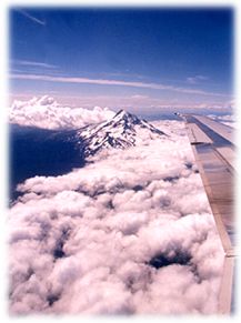 As
the plane neared Portland, we got a preview of what was in store for
us. Off to the south, a beautiful view of Mt. Hood, from above the clouds.
Clean, sharp, snowcapped, stunning. It was sunny and clear up there
... Once we landed, however, it was cloudy, misty and cool. As we left
the airport, I thought I had my camera at the ready. I didn't know I'd
be ambushed before we even reached the highway. Right on the airport
grounds were the most wonderful wooden horse sculptures — they
captured the horse "essence" perfectly. I was too transfixed
to reach the camera in time, and no where to stop or turn around. That
won't happen again, she vowed. As
the plane neared Portland, we got a preview of what was in store for
us. Off to the south, a beautiful view of Mt. Hood, from above the clouds.
Clean, sharp, snowcapped, stunning. It was sunny and clear up there
... Once we landed, however, it was cloudy, misty and cool. As we left
the airport, I thought I had my camera at the ready. I didn't know I'd
be ambushed before we even reached the highway. Right on the airport
grounds were the most wonderful wooden horse sculptures — they
captured the horse "essence" perfectly. I was too transfixed
to reach the camera in time, and no where to stop or turn around. That
won't happen again, she vowed.
The plan
was to follow the Columbia River Gorge east, all the way to The Dalles,
about 70 miles out. The gorge was actually a canyon cut by the Columbia
through the volcanic rock of the Cascades. I-84 ran along the river,
as did portions of the Historic Columbia River Highway, 30. Built between
1913 and 1920, the Highway's chief engineer Samuel Lancaster sought
to,"find those points where the most beautiful things along the
line might be seen ...and if possible, locate the road in such a way
as to reach them."
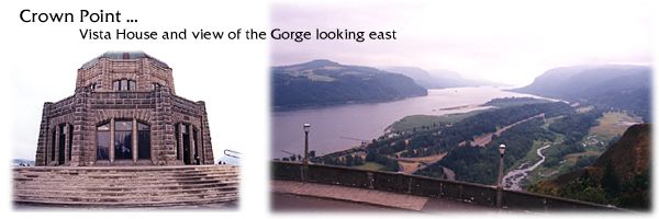
Somehow
we missed the first entrance to the old highway and had to backtrack
to get to Crown Point, we realized, as we saw the Vista House, a cylindrical
cap on a cliff, fade into the distance. We found an exit to Highway
30 and climbed our way back.
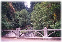
What a
great old roadway! Narrow, and with only the original low stone guardrail
between the pavement and some precipitous drops. It was a winding, steep
route up the 733 feet to Crown Point. Even with the mist, it was a spectacular
view, particularly looking east.
I'm compelled
to include these old postcards from the area. They convey the look and
especially the feel of this area so much better than my shots
or the modern cards. It was really a back-in-time atmosphere. Very special.
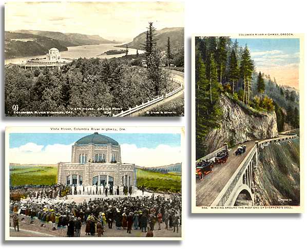
The Vista
House was dedicated in 1916. Inside we found a flea market in progress,
of all things, and a gift shop on the lower level. There was also a
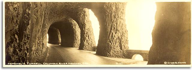
display of historic pictures and artifacts. (Including a picture of
Mitchell's Tunnel — I had seen it before, on an old postcard before
the trip, and was on a mission to find it — it looked incredible.)
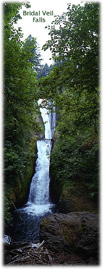 Back
on the old highway we retraced our route west, down to Bridal Veil State
Park. The sign said it was a half-mile hike to the Falls ... what it
didn't mention was how steep and rocky it was. Along the way we came
upon an older couple, slowly moving ahead. I felt badly for the lady
... she was struggling up and down the steep areas, where loose rocks
made the trek dangerous. But she gamely forged ahead. We heard the Falls,
and finally climbed a last slope and turned a bend, and voilà.
Very pretty, and we could see why it was so-named. On our hike back,
we passed a family; the kids were well-prepared in hiking boots, their
parents had on dress shoes; the father was sitting on a rock, emptying
pebbles from one. Back
on the old highway we retraced our route west, down to Bridal Veil State
Park. The sign said it was a half-mile hike to the Falls ... what it
didn't mention was how steep and rocky it was. Along the way we came
upon an older couple, slowly moving ahead. I felt badly for the lady
... she was struggling up and down the steep areas, where loose rocks
made the trek dangerous. But she gamely forged ahead. We heard the Falls,
and finally climbed a last slope and turned a bend, and voilà.
Very pretty, and we could see why it was so-named. On our hike back,
we passed a family; the kids were well-prepared in hiking boots, their
parents had on dress shoes; the father was sitting on a rock, emptying
pebbles from one.
Back on
Highway 30, we passed more tall, narrow waterfalls, including Multnomah
Falls with the historic stone Lodge in its shadow.
 The
long day was beginning to catch up with us as we arrived in Cascade
Locks, "the heart of the Gorge." A cute, small town right
on the river, with friendly looking shops and small restaurants. We
stopped for a late lunch (more like dinner to us) ... then spotted a
nice Best Western on the riverbank. Yes, they had a room — and
a great one at that, with a small balcony overlooking the river and
the Bridge of the Gods. More on that later.
We checked in, then were back out again, heading east. The
long day was beginning to catch up with us as we arrived in Cascade
Locks, "the heart of the Gorge." A cute, small town right
on the river, with friendly looking shops and small restaurants. We
stopped for a late lunch (more like dinner to us) ... then spotted a
nice Best Western on the riverbank. Yes, they had a room — and
a great one at that, with a small balcony overlooking the river and
the Bridge of the Gods. More on that later.
We checked in, then were back out again, heading east.
The old
highway seemed to disappear and we were back on I-84, paralleling the
river. I was still on my quest to find Mitchell's Tunnel ... but didn't
see it on the Gorge map. 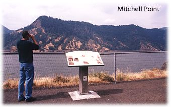 Ahead
was a high rock outcropping that had some kind of overlook. We turned
off and stopped, and approached the ledge above the river. The sign
said Mitchell Point and had information about the area and a picture
of the tunnel ... but then, where was it? Oh no. The sign's last
line: Sadly,
the tunnel was blasted away in 1966 to make way for Interstate 84.
Well, doggone it. Couldn't they have figured out some way to preserve
at least part of "one of the most famous engineering features of
the Highway?" I've since read that there is a wall fragment somewhere,
but we didn't see it. The five-window tunnel was cut out of solid rock,
390 feet long and 19 feet high. Here's what once was ... Ahead
was a high rock outcropping that had some kind of overlook. We turned
off and stopped, and approached the ledge above the river. The sign
said Mitchell Point and had information about the area and a picture
of the tunnel ... but then, where was it? Oh no. The sign's last
line: Sadly,
the tunnel was blasted away in 1966 to make way for Interstate 84.
Well, doggone it. Couldn't they have figured out some way to preserve
at least part of "one of the most famous engineering features of
the Highway?" I've since read that there is a wall fragment somewhere,
but we didn't see it. The five-window tunnel was cut out of solid rock,
390 feet long and 19 feet high. Here's what once was ...
Good thing
we had stopped at that overlook — I'd have gone crazy looking for
the tunnel otherwise. Peter was even more grateful, knowing the suffering
he'd have had to endure.
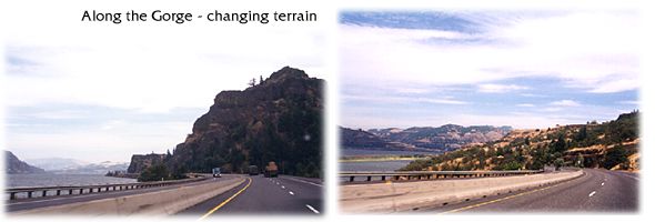
Ah well,
onward, eastward. The terrain was taking on a new look. From the towering,
angular green cliffs, to lower, rounder, browner terrain. It was also
getting warm and sunny ...

© 2000 CCarnovale
Home
| Web Design | Graphics
| Photos | Travels
|