 |
|
|
We drove west from San Juan. Just a few miles out of the aero puerto (love saying that), we had a quick realization: the drivers are terrible or crazy or both. We were almost rammed as a car raced up from behind and, at the last second, veered into the breakdown lane to pass us. That was our first inkling of what driving in Puerto Rico was like.
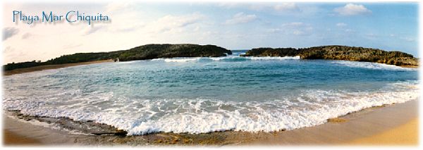
Well, that was all it took to send me on a quest for this place in our first hours on the island. There it was on the map, but darn, where is it? We twisted around several residential roads, and couldn't seem to ... ah, there it is ... The next problem was getting to it. After several more wrong turns, we finally got down to sand. Almost deserted, this was a beautiful beach. A unique rock formation enclosed the semicircular shore, with a gap in the middle. This created a tremendous vortex as the water funneled through. Waves crashed violently on the surrounding rocks — not a good place for a leisurely swim. We met a local woman who was very proud of her beach; she was interested to hear that I'd seen a picture of it on the Internet. She warned us to watch ourselves, as there had been incidents of tourists being robbed here. (Not that I looked like a tourist, I only had two cameras around my neck.)
Our first night was spent in Quebradillas, further west on the north coast, at Parador Guajataca, one of several government-run "country inns." They were originally planned as inexpensive lodges built in prime locations. Well, not so inexpensive anymore, but the location was still great.
Accommodations were interesting; each parador is unique in its architecture, but we would find the beds and bedding were standard issue. (Hard mattress, crunchy, plastic mattress pad.) This room was pleasant and light, and there was another spectacular beach just down a gentle slope.
After emerging we were back to the Puerto Rican countryside. The narrow, bumpy roads wound through lush, rolling mountains; and we saw several cattle farms.
Still
wandering the countryside, we found our way to the Arecibo Observatory
— the world's largest radio/radar telescope.

© 2000 CCarnovale Home | Web Pages | Graphics | Photos | Travels | At Home
|
 Our
first stop was at Playa Mar Chiquita. In planning our trip and trying
to learn more about Puerto Rico, I had come across this photo (right).

 On
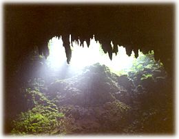
our second day in this area, we went south, inland to the Río Camuy
Cave Park
— one of the most "massive cave networks in the Western Hemisphere,"
along a portion of Río Camuy, one of largest subterranean rivers.
Lots of superlatives here. We went on a guided tour through the stalactites
and 'mites; some were huge formations. Then into the "bat cave"
where a few gazillion bats were hanging around. The air was noticeably
different — warmer,
sweeter, more humid.
 I'm
including an aerial view from a postcard because it's impossible to
take in from ground level. It's huge, with a 1000-foot diameter reflector
built into a natural sink hole. It's hard to know what to make of this
thing. Apparently, it's made some significant discoveries involving
quasars and pulsars (don't ask). And now it's always on the lookout
for transmissions or communications from "out there" —
and
people from their home Internet connections help track this also. So
far, no significant contacts ... Cornell operates this, and you may
wonder, why in Puerto Rico? Ideal observation latitude, at 17º
north of the equator.