
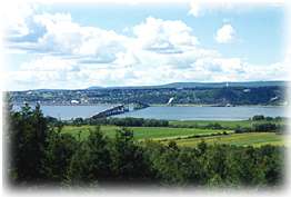
Just 15 minutes outside of Québec City is the bridge to Île d'Orléans, a beautiful island in the St. Lawrence River. As the guidebook says, it's "a well-preserved slice of rural Québec, more vieux than Vieux-Québec."
 We
crossed the only link to the island at its southwestern end and started
the circumferential drive on Route 368.The
island is 21 miles long and eight miles wide; the drive is a 41-mile loop,
with an almost continual view of the river (called the Chenal de Île
d'Orléans to the north) all the way around.
We
crossed the only link to the island at its southwestern end and started
the circumferential drive on Route 368.The
island is 21 miles long and eight miles wide; the drive is a 41-mile loop,
with an almost continual view of the river (called the Chenal de Île
d'Orléans to the north) all the way around.
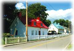
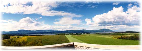
What a glorious place! Beautiful old farms, cottages, churches and villages. There are 7,000 year-round residents — many are descendents of French colonists who arrived in the 1640s. It's obvious they treasure and respect their ancestry. Today, the whole island is an historic district of the province.
Travelling southwest towards the tip, the ground is high above the river, so there are great views across to the Beaupré coast. We stopped at a small golf course in Sainte-Pétronille, one of the first built in North America. Then we rounded the bend and headed northeast up the southern coast.
 Now
we had good views of the Bas-Saint-Laurent shoreline across the river.
This was so nice. The weather was warm and sunny, and the pace was slow.
The old-world atmosphere set by the quaint homes and villages, and by
the people, was a true pleasure.
Now
we had good views of the Bas-Saint-Laurent shoreline across the river.
This was so nice. The weather was warm and sunny, and the pace was slow.
The old-world atmosphere set by the quaint homes and villages, and by
the people, was a true pleasure.
We stopped at a roadside store. Yum, after some homemade treats, we looked at all the wares, and walked to a small art studio in the field behind. A pretty spot.
 Everywhere
are homes with the colorful tin mansard roofs and wonderful wrap-around
porches — it made you happy just to look at these. There are six
separate village centers on the island. And between those, I was especially
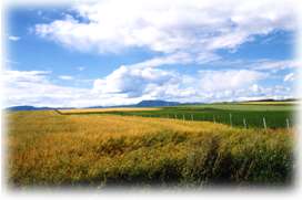
captivated by the acres of farmland set against the river and coasts beyond.
Everywhere
are homes with the colorful tin mansard roofs and wonderful wrap-around
porches — it made you happy just to look at these. There are six
separate village centers on the island. And between those, I was especially
captivated by the acres of farmland set against the river and coasts beyond.
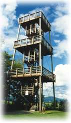 At
Saint-Francois on the northern tip, is an observation tower. I made the
climb and had spectacular views in all directions. Across the river to
the north, I could see Mt. Sainte-Anne and its ski trails. The southern
coast and a good part of the island itself were all there for the taking
— I could've stayed up there for a long time. I started thinking
about the rest of Québec. If it was this beautiful here, what must
it be like around the Gaspé peninsula,
further north?
At
Saint-Francois on the northern tip, is an observation tower. I made the
climb and had spectacular views in all directions. Across the river to
the north, I could see Mt. Sainte-Anne and its ski trails. The southern
coast and a good part of the island itself were all there for the taking
— I could've stayed up there for a long time. I started thinking
about the rest of Québec. If it was this beautiful here, what must
it be like around the Gaspé peninsula,
further north?
We continued down the north side of the island through more interesting country and pretty towns. Wouldn't it be great to have a vacation home here? What an idyllic place to get away to.
We left
the island, crossed back over the bridge and found ourselves facing Montmorency
Falls — a pretty amazing sight. 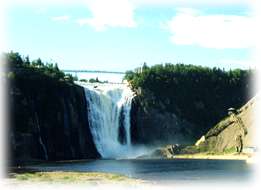 The
Montmorency River drops 272 feet before emptying into the St. Lawrence
here. Actually higher than Niagara Falls, though not nearly as wide. It
was interesting from below, but it would have been more exciting to be
on the cliff above, where there was a
beautiful manor overlooking the falls as well as a suspension bridge.
In winter the falls are incredible — not only do they freeze, but
the spray creates a "sugarloaf," a huge round mound of ice at
the base.
The
Montmorency River drops 272 feet before emptying into the St. Lawrence
here. Actually higher than Niagara Falls, though not nearly as wide. It
was interesting from below, but it would have been more exciting to be
on the cliff above, where there was a
beautiful manor overlooking the falls as well as a suspension bridge.
In winter the falls are incredible — not only do they freeze, but
the spray creates a "sugarloaf," a huge round mound of ice at
the base.
 We
headed back to Quebec City on our way to the hotel; and we couldn't resist
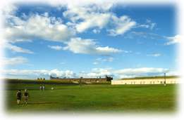
making another stop. At La Citadelle, a huge star-shaped fortress built
in 1834, long after it was needed for military purposes. Open, green and
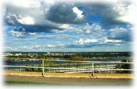
high atop the cliff above the river. The Promenade des Gouverneurs, an
extention of the Terrasse Dufferin, is a nice path along the cliff edge
overlooking the river and opposite shore. The Parc des Champs de Bataille
We
headed back to Quebec City on our way to the hotel; and we couldn't resist
making another stop. At La Citadelle, a huge star-shaped fortress built
in 1834, long after it was needed for military purposes. Open, green and
high atop the cliff above the river. The Promenade des Gouverneurs, an
extention of the Terrasse Dufferin, is a nice path along the cliff edge
overlooking the river and opposite shore. The Parc des Champs de Bataille
 is also here
— a huge park of vast green lawns and fields, with cannons sprinkled
about. A great place to run and roll.
is also here
— a huge park of vast green lawns and fields, with cannons sprinkled
about. A great place to run and roll.
It had been a long day of beautiful and interesting sights. The next morning we would be on our way to another great Canadian city ...