
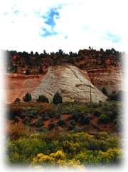
Well, after Zion and Bryce, how much more spectacular could a place be? We were about to find out. Our next stop would be the North Rim of the Grand Canyon. But instead of taking the most direct route from Bryce, we decided to go further east first — to see Lake Powell and the Glen Canyon Dam.
 On
the way, we passed through Kanab, Utah — a town that claimed to have "the
greatest earth on show," and with good reason. This drive through southern
Utah (Route 89), just north of and paralleling the Arizona border, was
vast and beautiful.
On
the way, we passed through Kanab, Utah — a town that claimed to have "the
greatest earth on show," and with good reason. This drive through southern
Utah (Route 89), just north of and paralleling the Arizona border, was
vast and beautiful.
Right at the Utah/Arizona border is a turnoff into part of the Glen Canyon National Recreation Area. Lone Rock Road leads right up to the shore of Lake Powell. The combination of light, clouds, and reflections at that moment was creating a riveting effect on the lake and Lone Rock. I'd never seen light and color quite like it. Despite being mostly overcast, the air was bright, luminous. We drove onto the sand (a la Daytona), joining a few other vehicles just hanging out.
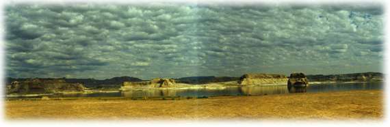
Just beyond
this is a long, bumpy turnoff that climbs to a great vantage point: the
lake, Wahweap Bay, the marina, the dam, and far off Navaho mountain are
all there in front of you. The lake has very few areas accessible by car, especially in this southern section — to really see it and
its spectacular geography, you need to travel by boat. That's another
item on the "next trip" list.
by car, especially in this southern section — to really see it and
its spectacular geography, you need to travel by boat. That's another
item on the "next trip" list.
We crossed over the Colorado River at the Glen Canyon Dam. Very much like the Hoover Dam in design, it plugged up the river and created Lake Powell behind it — 560 feet deep at the dam! Page, Arizona is the only town of any size for miles. It seems to be on a plateau and after ascending "up town," there are great views looking back at the lake and dam. Time to stock up on gas, snacks, and film in this nice-feeling place.
Now we're
getting into some serious geological elements. Huge mesas, 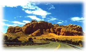 cliffs
and canyons were surrounding us. We were up, along, down, and back, maneuvering
about these formations, seeing the same areas from different sides. And
being far enough above or below these sculptures, we could see for miles
in all directions — what an wondrous, huge landscape to take in.
cliffs
and canyons were surrounding us. We were up, along, down, and back, maneuvering
about these formations, seeing the same areas from different sides. And
being far enough above or below these sculptures, we could see for miles
in all directions — what an wondrous, huge landscape to take in.
We crossed
over the river again, at Marble Canyon (near Lee's Ferry — more on
that later). A very orange area, with a few quaint old-west buildings.
Then along miles and miles and miles of the Vermillion
Cliffs. We were finally getting close to the North Rim, 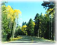 which
is only accessible from one road, one direction, through the beautiful
Kaibab National Forest. Because it was October, golden-leaved, white-barked
aspens lined Route 67 for miles. These mixed with the tall green pines
and spruces created a magnificent corridor to drive through. At last,
at last, we were almost at the Grand Canyon ...
which
is only accessible from one road, one direction, through the beautiful
Kaibab National Forest. Because it was October, golden-leaved, white-barked
aspens lined Route 67 for miles. These mixed with the tall green pines
and spruces created a magnificent corridor to drive through. At last,
at last, we were almost at the Grand Canyon ...
To the Grand Canyon - North Rim >