|
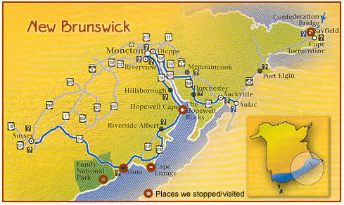
On to Fundy National Park ... we took the only road into and through
the park, found a place to stay in Alma, the only town around, then went
back in, prepared for a hike. But which hike? With only an afternoon to
spend, we decided on the Coastal hike, to get the most bang for the buck.
It was dense coastal forest (similar to Cape Lookout, Oregon), for almost two miles, with lots of ups and downs on rocky, rooted ground. Then we could feel the Bay getting closer. And finally we broke out of the trees to a beautiful clifftop view at Matthew's Head looking north to Alma. After returning to the trail start, we took a path down to Herring Cove, with the tide heading out. I had already begun the rock collecting in St. Martins ... and continued at this vast beach. We took to the car after that and went south to Point Wolfe where a covered bridge crossed the Point Wolfe River. A settlement was there in the 1800s and the remains of a sawmill still sits along the river. More on that here. Finding a place to eat in Alma proved to be a challenge; most places
were shut down after Labor Day — no grace period. Even in high season
there's not much there, but now, well, good luck. The most promising restaurant
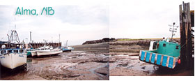
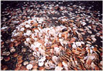
in a small hotel: closed. I'd heard a lot about Alma and the Fundy tides from my sister — she had taken several trips to, and spectacular photos of, this area. She'd also come home with giant scallop shells — so I was looking forward to doing the same. We didn't have the right footwear (where are those rubber boots when you need them?) but walked out of the harbor anyway, on the ocean floor — very neat. It was a mixture of rocks and Fundy mud, with channels and tidepools to navigate around. It was hard to actually see the water's edge, the tide receded that much, about a kilometer. We came to a few scallop-dump sites and I spent a while sifting through to find some nice shells; as usual I overloaded my bag, and also found rocks I wanted. As if I wasn't sinking in the mud enough already ...
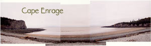
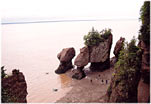
We continued to follow the Bay as it narrowed to the northeast. Our next stop was at Hopewell Cape, where the Bay flows into the Petitcodiac River. Because this was one of the narrowest points in the Bay, the tides were the highest here, over 40 feet. The big attraction, and one of the most popular in New Brunswick, are the Hopewell Rocks — huge freestanding columns and arches along a cliffside, all carved by the tides. Many of them have trees and other vegetation on top, thus the "flowerpot" rocks moniker. Click on any image to enter the photo pages:
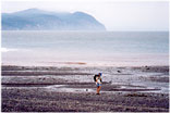
So after checking in at the park (i.e. paying admission), we were hiking to the coast where a wooden stairway went down to the bay. We were lucky, the tide was still low enough that we could walk around the formations. But we didn't have much time ... we went as far as possible, enjoying the incredible sculptures, then had to start back as the tide came relentlessly inward. There were "interpreters" there to round up and herd the visitors back up the stairs as the water closed in. To get the full experience you'd have to stay to high tide, as the water rises over 15 meters. Then go kayaking around the rocks — that was my thought when planning the trip, but alas, the timing was off. The kayak rental season had passed. But there was a large visitor center, with museum-quality exhibits explaining what's happening regarding tides, geology, animals, geography, history. Very nice. With the weather still dismal, we kept moving. Following the river, we stopped in Hillsborough at a small pottery studio located in back of the town post office. After circling the strange area around Moncton, we decided to continue over to Prince Edward Island. We stopped just short of the Confederation Bridge (1997) at yet another visitor center. There we had a good view of the massive 12.9 kilometer span across the Northumberland Strait. What an engineering feat ... |
|
|
|
 It
was as long as we wanted to make it. And after the steep, bumpy start
to the trail we weren't sure how far our dwindling energy would take us.
But it's funny how that works: once you get into it, get to thinking about
how lucky you are to be in such a place, with health and faculties intact
(relatively speaking), it's almost criminal not to make the most of the
opportunity. Sort of like your mother saying, "Clean your plate,
there are children starving in Africa."
It
was as long as we wanted to make it. And after the steep, bumpy start
to the trail we weren't sure how far our dwindling energy would take us.
But it's funny how that works: once you get into it, get to thinking about
how lucky you are to be in such a place, with health and faculties intact
(relatively speaking), it's almost criminal not to make the most of the
opportunity. Sort of like your mother saying, "Clean your plate,
there are children starving in Africa."